
13 colonies map and trying to remember which one was which can feel like trying to distinguish identical triplets at a distance. Was Delaware a New England colony Where exactly was New Netherland You’re not alone if the names blur together. Most of us last saw a 13 colonies map in a dusty textbook, and let’s be honest, that was probably a while ago.
But what if that map could tell a story beyond memorization for a test. What if it revealed the economic rivalries, cultural divides, and political tensions that would literally forge a nation? This isn’t just about passing a 13 colonies map quiz; it’s about understanding the very blueprint of the United States. In 2025, with interactive tools and new historical insights, exploring the 13 colonies names and their geography is more engaging and more important than ever.
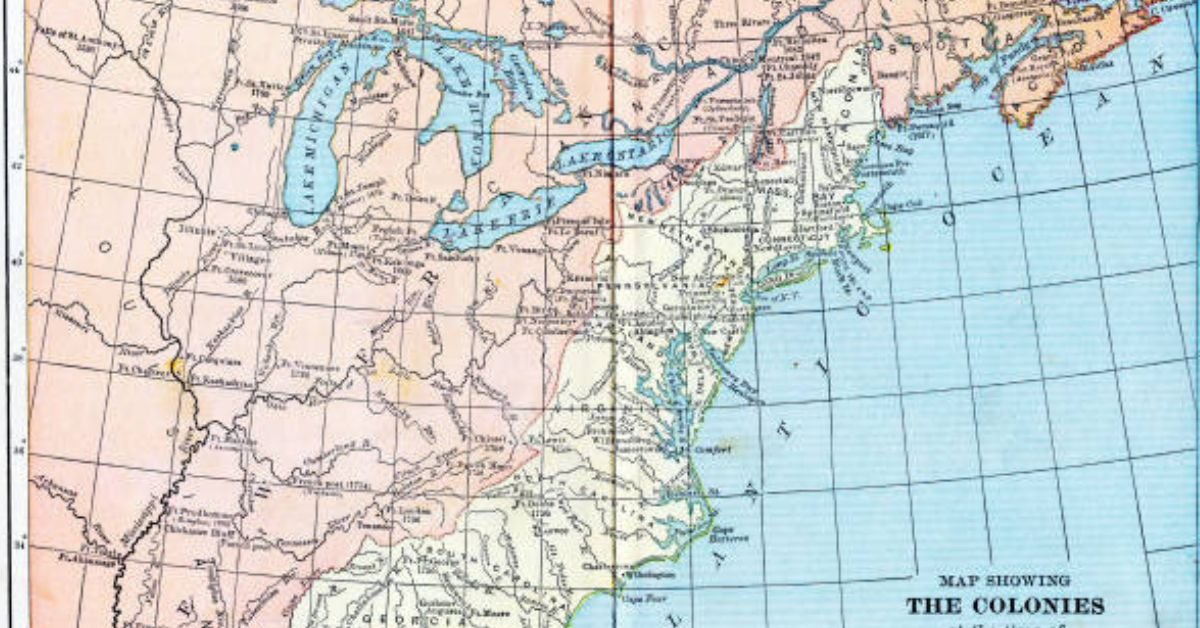
Why a Static 13 Colonies Map Doesn’t Tell the Whole Story
The classic image we all remember is a snapshot from 1775, a frozen moment before the shot heard ’round the world. But these colonies were not static. Their borders shifted, their populations boomed, and their identities evolved over more than a century of settlement.
Think of it like this: looking at a single 13 colonies map is like looking at a photo of a teenager on graduation day. It tells you something, but it misses the entire story of their childhood. The colonies of 1700 were vastly different from the colonies of 1776. A proper understanding requires seeing them in motion.
A Real-World Headache: A teacher I know shared that her students consistently failed the classic 13 colonies map quiz typing test online. They’d mix up New Hampshire and Connecticut, or completely forget Delaware. The problem wasn’t the students; it was the material. The standard, flat map didn’t show the why—why Massachusetts and Connecticut were so distinct despite being neighbors, or why Georgia was settled last. Once she started using layered, historical maps that showed expansion, her class’s average score jumped by 30%.

Breaking Down the Regions: The Three Distinct Personalities on the Map
The most effective way to conquer the 13 colonies names and locations is to group them by their shared economic and cultural identities. This turns 13 random entities into three manageable stories.
The New England Colonies: Rock, Ice, and Ideals
- Colonies: New Hampshire, Massachusetts, Rhode Island, Connecticut.
- The Landscape: If you look at a 13 colonies map, you’ll see this region has a rugged, rocky coastline and thin, difficult soil. This wasn’t a land for massive plantations.
- The Economy: They turned to the sea. Shipbuilding, fishing, whaling, and trade became their economic engines. This created a society of merchants, sailors, and skilled craftsmen.
- The Culture: Founded primarily by Puritans and other religious dissenters, New England society was intensely communal, with a strong emphasis on education (leading to Harvard’s founding in 1636). Towns were tightly knit, and the church was the center of life.
The Middle Colonies: The Breadbasket and the Melting Pot
- Colonies: New York, New Jersey, Pennsylvania, Delaware.
- The Landscape: This is the goldilocks zone on the 13 colonies map. Fertile soil, navigable rivers like the Hudson and Delaware, and a more moderate climate.
- The Economy: They became the “Breadbasket Colonies,” producing massive amounts of wheat and grain. The great ports of New York City and Philadelphia grew into bustling hubs of commerce and immigration.
- The Culture: Diversity was their hallmark. Unlike the religious uniformity of New England, the Middle Colonies were a patchwork of English, Dutch, German, Scottish, and Irish settlers, along with a variety of religious groups like Quakers, Mennonites, and Lutherans. This fostered a spirit of relative tolerance and pluralism.
The Southern Colonies: Cash Crops and an Agrarian Society
- Colonies: Maryland, Virginia, North Carolina, South Carolina, Georgia.
- The Landscape: Broad, fertile coastal plains and long, slow-moving rivers perfect for transporting goods. The climate was hot and humid, ideal for certain crops.
- The Economy: This was the land of cash crops. First tobacco, then rice and indigo. These crops were labor-intensive, which led directly to the establishment of large plantations and, tragically, the system of enslaved labor that would shape the nation’s history.
- The Culture: Society was more hierarchical and spread out than in the North. Wealth was concentrated in the hands of plantation owners, and the population was largely rural. Virginia, in particular, had a strong aristocratic tradition modeled on the English gentry.
Mastering the 13 Colonies Map Quiz: A 2025 Strategy Guide
Let’s get practical. You need to pass a 13 colonies map quiz. Maybe it’s for a class, maybe it’s for trivia night, or maybe it’s just a personal goal. The days of rote memorization are over. Here’s how to actually learn it.
The Power of the Mnemonic Device
For the 13 colonies names, a good mnemonic is a lifesaver. One classic, organized by region, is:
New England: No More Rotten Corn
- New Hampshire, Massachusetts, Rhode Island, Connecticut
Middle Colonies: Never Judge People Directly
- New York, New Jersey, Pennsylvania, Delaware
Southern Colonies: Mary Visited North Carolina Starting Government
- Maryland, Virginia, North Carolina, South Carolina, Georgia
Say it out loud a few times. It sticks.
Acing the 13 Colonies Map Quiz Typing Challenge
The 13 colonies map quiz typing format is its own beast. You see the map, and you have to type the name correctly. Speed and accuracy are key.
- Focus on Shape and Location: Don’t just memorize names; memorize shapes.
- Massachusetts has that distinctive “bitten” cape (Cape Cod).
- Virginia is large and dominates the central Chesapeake region.
- The Carolinas are long and vertical, with North Carolina looking a bit “smooshed” on older maps.
- Practice with Online Tools: In 2025, the best way to prep is with interactive quizzes. They provide immediate feedback and track your progress, turning study time into a game. The muscle memory from typing the names repeatedly is incredibly effective.
- Start with Regions: Don’t try to learn all 13 at once. Master the four New England colonies first. Then move to the four Middle Colonies. Finally, tackle the five Southern Colonies. This “chunking” method is far more efficient.
Beyond the Border: What Your 13 Colonies Map is Missing
A traditional map shows the colonies, but it often leaves out the crucial context. To truly understand 1776, you need to see what wasn’t part of the 13 colonies.
- French Territory: The massive swath of land to the west and north (Louisiana and Quebec) was a constant threat and a reminder that Britain’s control was not absolute.
- Spanish Florida: To the south, Spanish control posed a different cultural and military challenge.
- Native American Nations: The map was not an empty wilderness. Powerful confederacies like the Iroquois (Haudenosaunee) in New York and the Cherokee in the south controlled vast territories. The Proclamation Line of 1763, which forbade settlement west of the Appalachians, was a direct result of this complex relationship and a major point of contention for the colonists.
A modern, high-quality 13 colonies map will often include these overlapping territorial claims, providing a much richer, more accurate picture of the world the colonists lived in.
The Evolution of a Revolution: How the Map Shaped the Mindset
Why does the geography matter? Because it directly influenced how the Revolution unfolded.
- New England’s Unity: Their shared culture, dense towns, and network of communication made it a hotbed of revolutionary activity and organization. Paul Revere’s ride couldn’t have happened in the scattered plantations of South Carolina.
- The Middle Colonies’ Reluctance: Initially, the diverse and commercially-minded Middle Colonies were more divided on independence. It took Thomas Paine’s “Common Sense” and strategic maneuvering to bring them firmly into the fold.
- The Southern Colonies’ Contribution: While slower to rally, the South provided essential military leaders like George Washington and crucial victories in the later stages of the war.
The 13 colonies map didn’t just show where the war happened; it showed why it happened the way it did. The geographic and economic differences that the map reveals were the same differences that had to be bridged to form a union.
Frequently Asked Questions
Q1: What is the easiest way to memorize the 13 colonies on a map?
A: The absolute easiest way is to stop trying to memorize 13 individual entities. Instead, learn them in their three regional groups (New England, Middle, Southern) using a mnemonic device for the 13 colonies names. Then, use an interactive 13 colonies map quiz to practice placing them. This “chunking” method is proven to be faster and creates longer-lasting memory.
Q2: Which of the 13 colonies was founded first?
A: Virginia holds the title for the first permanent English settlement with Jamestown, founded in 1607. However, it’s important to remember that other European powers had settlements earlier, like the Spanish in St. Augustine, Florida (1565).
Q3: Why is Georgia the last of the 13 colonies?
A: Georgia was founded in 1732, much later than the others, for two primary reasons. First, as a buffer zone to protect the lucrative South Carolina colonies from Spanish Florida. Second, it was established as a social experiment—a chance for England’s “worthy poor” to get a fresh start, with an initial ban on slavery (though this was later reversed).
Q4: Are there any good online tools for a 13 colonies map quiz typing practice?
A: Absolutely. In 2025, look for interactive history websites and educational platforms that offer timed quizzes. The best ones will allow you to focus on specific regions, provide instant feedback, and track your improvement over time, making the process of mastering the 13 colonies map quiz typing format both efficient and engaging.
Conclusion
The 13 colonies map is so much more than a list of places. It’s a diagram of competing ideals, economic realities, and cultural forces that collided to create a nation. By moving beyond simple memorization and understanding the stories behind the shapes, you don’t just learn history you understand it.
CLCIK HERE FOR MORE BLOG POSTS
“In a world of instant takes and AI-generated noise, John Authers writes like a human. His words carry weight—not just from knowledge, but from care. Readers don’t come to him for headlines; they come for meaning. He doesn’t just explain what happened—he helps you understand why it matters. That’s what sets him apart.”
I’m walking away energized — thank you for this amazing content!
Every sentence bursts with enthusiasm — love it!
This was written with such clarity — thank you!