
Most people have heard of Kīlauea’s famous East Rift Zone. Few realize that another volcanic corridor stretches southwest from the summit and has quietly shaped Hawaii’s landscape for centuries.
That corridor is the Southwest Rift Zone.
For decades it remained overshadowed by more active volcanic regions. Then a significant eruption in 2024 reminded scientists and the public that this area remains very much alive. Nearly fifty years after its previous eruption, the Southwest Rift Zone suddenly returned to the spotlight.
What Is the Southwest Rift Zone?
The Southwest Rift Zone (SWRZ) is one of two major rift zones extending outward from Kīlauea Volcano.
A rift zone is essentially a weakened section of a volcano where magma can travel more easily toward the surface. These areas develop networks of fractures, cracks, fissures, and volcanic vents that act as natural pathways for molten rock.
The Southwest Rift Zone extends southwest from Kīlauea’s summit region toward the coast and has a length of roughly 40 kilometers (about 25 miles).
Key Characteristics
- Extends southwest from Halemaʻumaʻu
- Contains numerous fissures and vents
- Mostly located within Hawaii Volcanoes National Park
- Less vegetated than the East Rift Zone
- Historically less active but still hazardous
- Serves as a major magma transport pathway
Visual Section: Southwest Rift Zone at a Glance
| Feature | Southwest Rift Zone | East Rift Zone |
|---|---|---|
| Length | ~40 km | ~50 km on land |
| Activity Level | Less frequent | Historically more active |
| Major Recent Eruption | 2024 | 2018 |
| Vegetation | Sparse | Dense |
| Accessibility | Limited | More accessible |
| Public Awareness | Lower | Higher |
Data compiled from USGS and Hawaiian Volcano Observatory reports.
Why Rift Zones Exist
Volcanoes are not solid mountains.
They constantly expand, settle, crack, and deform under immense internal pressure.
As magma accumulates beneath a volcano, stress develops along predictable directions. Over time, these stresses create elongated weak zones where magma can intrude. These become rift zones.
Scientists describe rift zones as the volcano’s preferred escape routes.
When pressure builds, magma often travels through these corridors before reaching the surface.
The Geological Importance of the Southwest Rift Zone
One reason geologists love studying the Southwest Rift Zone is visibility.
Unlike the heavily forested East Rift Zone, much of the Southwest Rift Zone lies within the Kaʻū Desert, where sparse vegetation exposes ancient lava flows and volcanic deposits.
This allows researchers to reconstruct centuries of volcanic history with remarkable accuracy.
Notable features include:
- Great Crack
- Kamakaiʻa Hills
- Puʻukoaʻe
- Mauna Iki lava fields
- Keanakākoʻi tephra deposits
These features preserve evidence of both explosive and effusive eruptions spanning hundreds of years.
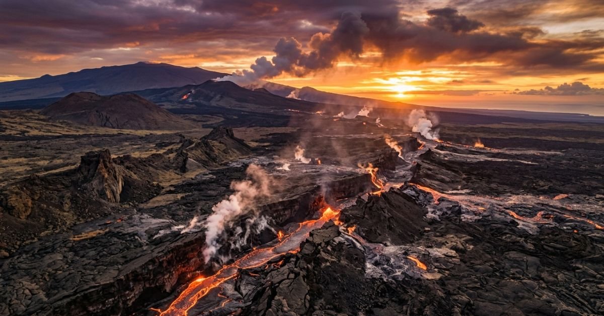
The 2024 Southwest Rift Zone Eruption
The biggest recent development occurred on June 3, 2024.
Kīlauea’s Southwest Rift Zone erupted for the first time since 1974.
The eruption began along a fissure system approximately one kilometer long and produced lava fountains and flows within Hawaii Volcanoes National Park. Although dramatic, the eruption lasted only a few hours before activity diminished.
Why the 2024 Event Matters
- First SWRZ eruption in nearly 50 years
- Confirmed ongoing magma movement beneath the region
- Provided new monitoring data
- Renewed scientific interest in long-term hazard assessment
- Validated forecasts suggesting future activity remained possible
Scientists had long warned that the lack of recent eruptions did not mean the Southwest Rift Zone was extinct. The 2024 eruption confirmed those concerns.
Historical Eruptions of the Southwest Rift Zone
The Southwest Rift Zone has produced numerous eruptions over the past several centuries.
Notable Events
| Year | Event |
| 1790 | Explosive eruption period |
| 1823 | Keaīwa lava flow |
| 1868 | Rift zone eruption |
| 1919–1920 | Mauna Iki eruption |
| 1971 | Short-lived eruption |
| 1974 | Major fissure eruption |
| 2024 | First eruption in 50 years |
These eruptions demonstrate that activity occurs intermittently rather than continuously.
Volcanic Hazards Associated With the Southwest Rift Zone
Although much of the zone lies within protected parkland, future eruptions still pose risks.
Potential hazards include:
Lava Flows
Fast-moving lava can cross roads and damage infrastructure.
Volcanic Gas
Sulfur dioxide emissions may affect air quality and public health.
Ground Cracking
Magma intrusion can create new fissures and fractures.
Earthquakes
Rising magma often triggers earthquake swarms before eruptions.
Myth vs Fact
Myth:
The Southwest Rift Zone is dormant.
Fact:
The 2024 eruption proved it remains active and capable of producing future eruptions.
Myth:
Only the East Rift Zone matters.
Fact:
Both rift zones serve as critical magma pathways and influence Kīlauea’s eruptive behavior.
Myth:
Rift zones are simply cracks in the ground.
Fact:
They are complex geological systems involving magma transport, faulting, deformation, and repeated volcanic activity.
Key Statistics
Southwest Rift Zone Facts
- Approximate length: 40 km (25 miles)
- Last eruption before 2024: December 1974
- Years between eruptions: Nearly 50 years
- 2024 fissure system length: Approximately 1 km
- Major eruptions documented since the 1800s: Multiple confirmed events
EEAT Section: Insights From Volcanology Research
One of the most common misconceptions among the public is that a volcano becomes safe simply because it has been quiet for decades.
Volcanologists know the opposite can be true.
The Southwest Rift Zone illustrates this perfectly. Scientific mapping, deformation monitoring, earthquake tracking, gas measurements, and historical records all indicated the system remained capable of future activity long before the 2024 eruption occurred. The lesson is simple: volcanic hazards are measured through ongoing observation, not by the length of time since the last eruption.
Frequently Asked Questions
What is the Southwest Rift Zone?
The Southwest Rift Zone is a major volcanic fracture system extending southwest from Kīlauea Volcano. It acts as a pathway that allows magma to move from underground reservoirs toward the surface during eruptions.
Where is the Southwest Rift Zone located?
It is located on Hawaii’s Big Island and extends southwest from Kīlauea’s summit region through Hawaii Volcanoes National Park toward the coast.
When did the Southwest Rift Zone last erupt?
The most recent eruption occurred on June 3, 2024. Before that, the last eruption was in December 1974.
Why is the Southwest Rift Zone important?
It provides scientists with valuable information about magma movement, volcanic hazards, eruption forecasting, and the long-term evolution of Kīlauea Volcano.
Is the Southwest Rift Zone dangerous?
Like any active volcanic region, it can produce lava flows, volcanic gas emissions, earthquakes, and ground cracking. Risk levels vary depending on eruption location and intensity.
How is the Southwest Rift Zone monitored?
Scientists use earthquake sensors, GPS stations, gas monitoring systems, satellite imagery, and field observations to track volcanic activity and detect early warning signs.
Final Thoughts
The Southwest Rift Zone may not receive the same attention as Kīlauea’s East Rift Zone, but it remains one of Hawaii’s most important volcanic features.
From the Great Crack and Keanakākoʻi tephra deposits to the 2024 eruption that ended nearly five decades of silence, the Southwest Rift Zone offers a remarkable window into how volcanoes grow, deform, and erupt.
CLICK HERE FOR MORE BLOG POSTS
“In a world of instant takes and AI-generated noise, John Authers writes like a human. His words carry weight—not just from knowledge, but from care. Readers don’t come to him for headlines; they come for meaning. He doesn’t just explain what happened—he helps you understand why it matters. That’s what sets him apart.”